
Langley City Real Estate & Community Guide
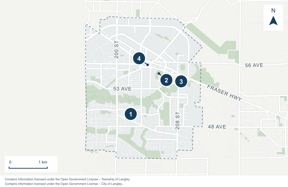
Find your bearings
Langley City at a glance
- 1Sendall Gardens201A Street / 50 Avenue
- 2Douglas Park206 Street / Douglas Crescent
- 3Nicomekl Park208 Street / 54 Avenue
- 4Timms Community Centre20399 Douglas Crescent
Outline follows the City of Langley boundary. This orientation map shows approximate landmark locations, not entrances, school catchments or real estate search boundaries.
Contains information licensed under the Open Government License – Township of Langley. Contains information licensed under the Open Government License – City of Langley.
“Langley City deserves a closer look if you want an urban setting where shops, streets and transport help shape everyday life. I find it busier and denser than many Township neighbourhoods. In my experience, buyers weigh that convenience against noise, parking and the character of the immediate block.” — Scott Strudwick
Local perspective contributed by Scott Strudwick, Strudwick Team. Editorial draft updated October 27, 2026; final wording awaits Scott’s review.
Living in Langley City: Quick overview
- Location
- City of Langley, separate from the Township of Langley, British Columbia.
- Homes and setting
- An urban setting with apartments, townhouses and detached properties.
- Who may enjoy living here
- Buyers who value shops, cafés and transport connections.
- What to consider
- The building and block, strata records, current zoning and today’s transport versus future SkyTrain.
Think about the places you'd like to walk to, the space you need at home and your commute today. As you compare properties, confirm whether the address is in Langley City or the Township so you use the right planning information.
Langley City: Shops, cafés and urban living
We see the downtown shopping streets, cafés and independent eateries as a big part of the City's appeal. Someone wanting more everyday trips on foot may value this differently from a buyer seeking a larger yard. Keep downtown Langley City and the nearby Willowbrook shopping area distinct when planning errands; try the routes to both from the home you are considering.
Pick one regular errand or walk and follow it from the home you are considering. Notice the building exit, parking access, street crossings and the return with shopping. Choose the stops you would use regularly to get a feel for the neighbourhood.
Give the immediate block its own visit. Look at deliveries, outdoor space, nearby activity and the light at the time you would occupy the home. Take a few notes so you can compare the setting with the other homes you visit.
If you are exploring other neighbourhoods, keep the lifestyle you want in mind. The Murrayville guide gives you a civic-core comparison, while the Willoughby guide focuses on townhouse choices and a different planning context. A short list of must-haves will help you compare the options.
Try the trip at the time you expect to use it, including the return after dark if relevant to your routine. Check the entrance, crossings and final walk with shopping. See how comfortable and convenient the route feels to you.
What to compare in a Langley City property
For an apartment, give the unit's position its own assessment: relationship to entrances, elevators, service areas and neighbouring balconies, as well as light and outdoor space. Alongside the finishes, look into the condition of the shared building components. Ask what maintenance is planned and how it would be funded, alongside the current monthly costs.
Thinking about buying a home to renovate, adding a suite or shop, or building a new home? Talk with Strudwick Team first. Share the address and what you have in mind. We can help you understand the zoning, spot property constraints and work through the next steps before you spend time on a home that may not suit your plans. Any required permits, municipal approvals and specialist assessments still need to be confirmed for the project.
Homes and plans around the Nicomekl River
The City's Nicomekl River District plan covers an area between 196 and 208 Streets, with boundaries that vary. It describes a transition in housing forms across the district. Use it to understand the area’s planning direction, then check the rules for the address you are considering.
For a candidate address, find the river crossing and trail entrance you would actually use. Mark future rail access separately: the project office places Langley City Centre Station east of 203 Street and Industrial Avenue. Check the route from the home and remember that the station is not operating yet.
For an apartment or townhouse, begin with how the unit works inside the building. Test the route from parking to the entrance, storage access and where everyday equipment would go. Check room dimensions against the furniture you plan to keep. If outdoor space is a priority, measure how you would actually use it instead of comparing balcony or patio labels alone.
Building records belong beside the floor plan in the decision. BCFSA explains that a Form B provides information about strata fees, finances and parking or storage arrangements. Obtain the relevant current records and seek appropriate professional advice on questions that materially affect the purchase.
For a detached property, shift the comparison to the house, outdoor area and responsibilities you would take on directly. Review the condition and documentation of improvements. If your purchase depends on adding space or changing a use, talk with us about the address first. We can help you assess the zoning and identify any municipal approvals or specialist advice needed before you build the assumption into your budget.
The City's planning page records a new zoning bylaw adopted in March 2026. If you are planning to build or change a property’s use, speak with us first about the address and your plans. Use the official planning and zoning links as source information; we can help you interpret it and identify any details that need confirmation from City staff. Get those answers before committing to a project.
Price the individual property
Use recent relevant completed sales and compare the property type, condition, layout and location. We can help you identify the sales that best match your home.
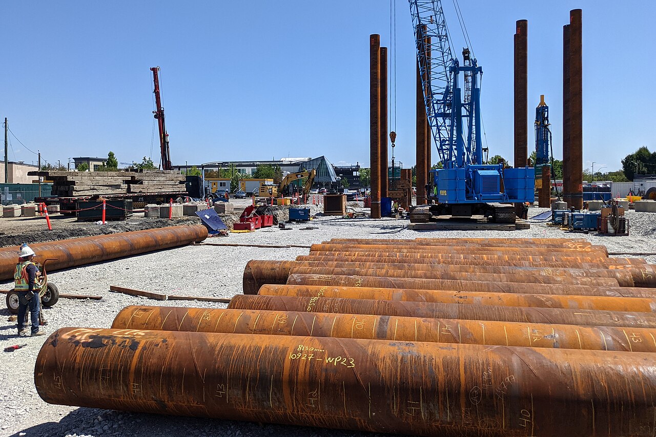
Langley City Centre station construction, July 2025. This photograph records work at that time, not the current stage of construction.
Northwest. CC BY 4.0 · Original photograph. Image resized proportionally; no crop or colour changes.
Walk the parks and check today's travel
Sendall Gardens sits at 201A Street and 50 Avenue, with gardens, trails and Muckle Creek. Nicomekl Park, at 208 Street and 54 Avenue, provides an entry to floodplain walking trails. Leave time to explore them during your visit, and check the City's pages for current access and facility information.
When a property is marketed around nearby green space, check the route to the actual entrance and visit the part you expect to use. If the location raises a question about floodplain restrictions or site conditions, use the City's mapping resources with our help to identify the questions that need confirmation from the City or relevant specialists for that address. Confirm any flood exposure, building restrictions and insurance questions for the property before you commit.
For school planning, search the exact address in the SD35 School Locator and confirm arrangements with the district. For existing transit, enter your normal times and destinations in the TransLink Trip Planner. Compare the complete outbound and return trips, including the walk at each end.
The Surrey Langley SkyTrain project is under construction and currently anticipates service in late 2029. As of October 20, 2026, service is still in the future and the opening date may change. Make sure the home works with your transport options today.
The project's station information places Langley City Centre Station east of 203 Street and Industrial Avenue, and Willowbrook Station at the northeast corner of 196 Street and Fraser Highway. Check the planned location and route against the actual home rather than assuming a station name establishes convenient walking access.
Compare a normal weekday trip with a late return if both matter to you. Keep that observation separate from the future SkyTrain plan when deciding whether a home works now.
Selling your Langley City home
These three questions can help us plan your sale:
- Which sales are relevant? For a strata home, compare the building, unit and condition, not just bedroom count. For a detached property, ask how the land and improvements affect the comparison.
- What should buyers see? Prepare a floor plan, improvement records, included-item details and accurate parking, storage and ownership information.
- How will future changes be described? Keep planned transit or nearby development distinct from conditions today. Avoid promised travel times, returns or future values.
Request a Langley City home evaluation with your address, property type and preferred timing. Our selling guide explains the broader process. Use the first meeting to understand the pricing evidence, preparation priorities and communication you would receive throughout the listing.
How Strudwick Team can help in Langley City
We can help you compare the home and its surroundings, from an apartment’s position in the building to parking, storage and nearby activity. We can also help organize the strata information and relevant sales for your decision, keeping current amenities separate from future SkyTrain plans.
Langley City buyer and seller FAQs
Who might prefer Langley City to a Township neighbourhood?
We suggest considering its urban setting if you value shops, amenities and transport connections. Compare the particular block's noise, parking and walking routes against the outdoor space and setting you want.
Is SkyTrain operating in Langley City now?
No. Official Surrey Langley SkyTrain information checked October 20, 2026 anticipates service in late 2029. Assess today's commute separately and recheck the timetable before relying on it.
Where is Langley City Centre Station planned?
The Surrey Langley SkyTrain project places Langley City Centre Station east of 203 Street and Industrial Avenue. Check the planned location and route from the property rather than assuming every City home will be a convenient walk away.
What should you check when buying a Langley City apartment?
Compare the unit and its position in the building with current strata records, costs, parking and storage. Resolve material questions about maintenance, rules and intended use before relying on assumptions.
Can you use Township zoning information for a City property?
No. Confirm the municipality for the address and use Langley City's planning and zoning resources for a City property. Bring specific building or use questions to us first. We can help you understand the applicable rules and identify any required confirmation from the City.
Does future SkyTrain guarantee a property value increase?
No. Describe the verified project and its anticipated status separately from pricing or investment expectations. A property-specific assessment is needed; proximity to planned transit does not guarantee a return.
Talk with us about your Langley City move. If you are starting a search, our buying guide can help you organize your shortlist and next questions.
 The data relating to real estate on this website comes in part from the MLS® Reciprocity program of either the Greater Vancouver REALTORS® (GVR), the Fraser Valley Real Estate Board (FVREB) or the Chilliwack and District Real Estate Board (CADREB). Real estate listings held by participating real estate firms are marked with the MLS® logo and detailed information about the listing includes the name of the listing agent. This representation is based in whole or part on data generated by either the GVR, the FVREB or the CADREB which assumes no responsibility for its accuracy. The materials contained on this page may not be reproduced without the express written consent of either the GVR, the FVREB or the CADREB.
